|
Trail Maps
For more maps/info including photos, see Friends of the Huckleberry
About the Trail
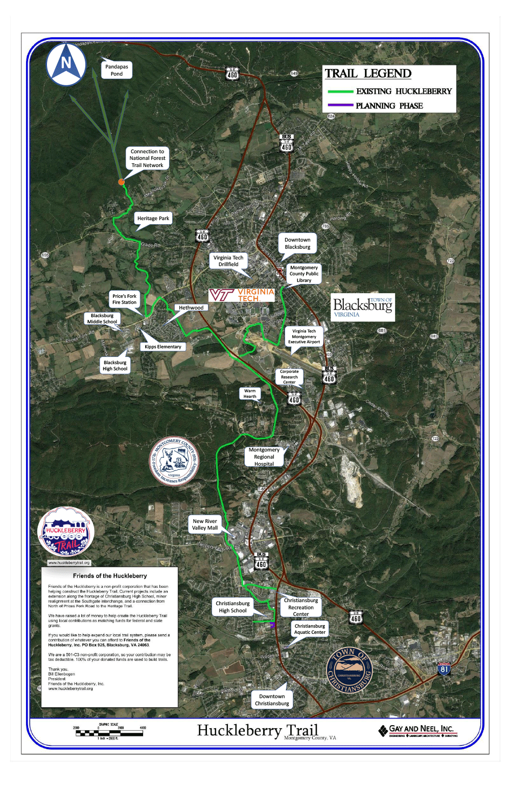
The original portion of the Huckleberry Trail runs between Blacksburg and Christiansburg. Once the original section was completed, the trail was expanded and now consists of the original portion and two additional segments known as Huckleberry North and Huckleberry South. Together, the three segments of paved trail are almost 15 miles in length.
- The original Huckleberry Trail begins at the Blacksburg Public Library (on Miller Street) and winds through the Virginia Tech campus, Montgomery County, and ends at the Christiansburg Recreation Center. This segment of the trail is approximately 8.25 miles in length.
- Huckleberry North begins at the trail roundabout west of Route 460 and ends at Heritage Park on the north side of Blacksburg. This trail segment is approximately 5 miles in length.
- Huckleberry South begins on Cambria Street in Christiansburg and winds through residential neighborhoods to Christiansburg High School. This segment is approximately 1.4 miles in length.
The Huckleberry connects to Gateway Trail, Poverty Creek Trail System, McDonald Hollow Trail System, and the Coal Mining Heritage Trail. In total, the trail network includes 60+ miles of trail.
Articles and Updates
The above description was valid and complete through August, 2021. Below, in reverse chronological order, are notices and links about developments on the Huckleberry trail and other local trails.
September 12, 2021: New maps, additional mile markers latest steps for Huckleberry Trail (Roanoke Times). May 2, 2021: First Brush Mountain Park trails open (Roanoke Times). December 6, 2020: New Friends of the Huckleberry president looks to fill ‘big shoes’ (Roanoke Times). August 18, 2020: New Blacksburg Trail System - Brush Mountain Phase I Phase 1 of the Brush Mountain Trails Project is nearing completion. Our contractor and volunteers built 2.3 miles of new multi-use trails on Property 1. With upgrades to the existing roadbed, there are now 5 miles of trails for hiking, mountain biking, horseback riding, and running, minutes from downtown Blacksburg.
Volunteers are now finishing up the trails by hand. Working with the Town of Blacksburg, we hope to open the trails to the public this fall. In the meantime, please check out the video for a peek at the trails and to learn more about the project.
November 15, 2019: The Huckleberry: More than just a trail (Virginia Tech Daily). May 24, 2019: Long-awaited Huckleberry extension in Blacksburg almost ready (Roanoke Times). January 12, 2019: Blacksburg on the move: Huckleberry Trail bridge written into improvements plan linking a network of greenspace planning (News Messenger, Blacksburg, Christiansburg). -
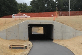
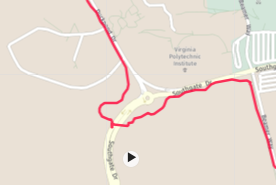
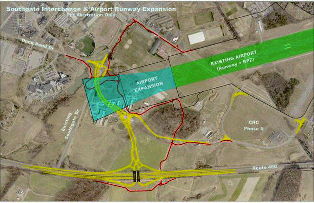
July 29, 2018: Tunnel under new Southgate: This tunnel, paid for as a part of the VDOT Southgate interchange project, is under Southgate. The path is now paved from the new turnaround on the new part of the HT that runs along Southgate, through the tunnel, up to Duckpond Road, and finally joining with existing bike paths. The picture of the tunnel is from the Vet-School side. The Garmin-Connect path in the map does not include the roundabout; it goes directly to the tunnel on a partially-unpaved stretch from the paved path along Southgate
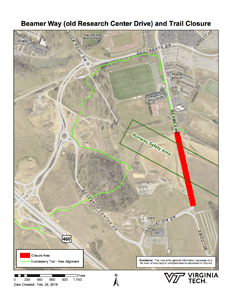 |
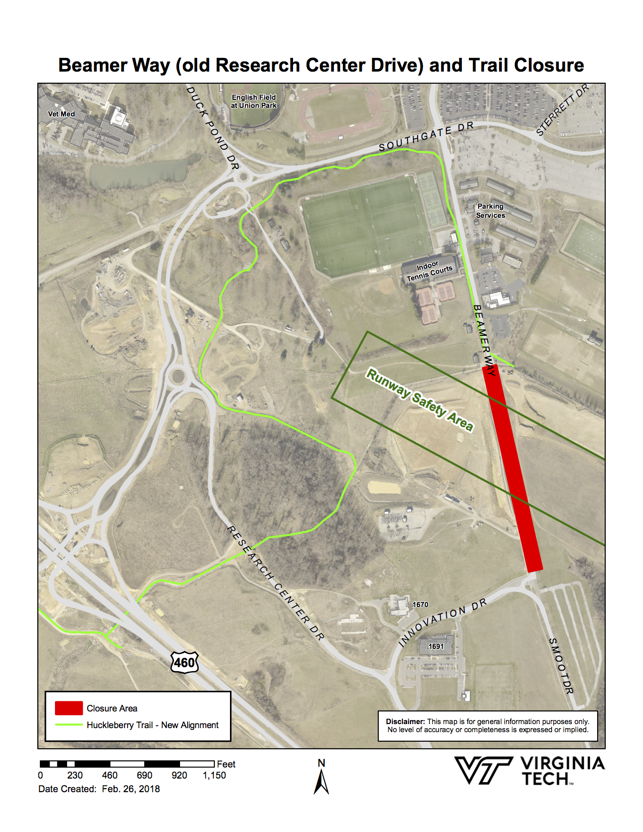
February 27, 2018: From VT News: VDOT to close old Research Center Drive. On March 7 (between 9:30 and noon) a section of Research Center Drive was closed (see map at left). That section of road will be leveled to allow the extension of the Runway Safety Area.
The portion of the road from Southgate Drive to the Upper Recreation Area parking lot (near the Burrows-Burleson Tennis Center) will remain open as an extension of Beamer Way. The portion of the road from Forecast Drive to Innovation Drive will remain open as Smoot Drive. What was called Discovery Drive will now be a part of the (new) Research Center Drive. |
Trail users will no longer be able to turn south at the intersection of the trail with (old) Research Center Drive and then turn right at Innovation Derive. From now on, coming from the 1-ile mark trail users will have to cross the road and turn right, along the Beamer Way extension (down Chicken Hil) to Southgate. Then they will use the new section of trail that goes along Southgate Drive and along the new Research Center Drive. Compared to a year ago, these changes in the Huckleberry Trail add one hill and about 0.84 miles.
January 13, 2018: Christiansburg, Blacksburg moving to expand Huckleberry this year (Roanoke Times). December 24, 2017: Bill Ellenbogen (President, Friends of the Huckleberry) wrote
“This spring, when the construction has been completed and mileage can be accurately determined, the mile markers on the Huckleberry Trail will be relocated. 6 and 7 mile markers will be added to the section between New River Valley Mall and the Christiansburg Recreation Center.
Mile markers will also be added to the Huckleberry North Trail, the section from west of the tunnel to the Gateway Park at the base of Brush Mt.
The Town will complete the Huckleberry North Trail between Prices Fork Road and Glade Road in 2018. Money has been appropriated by the Town and bidding for the project is now underway.”
 |
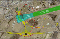
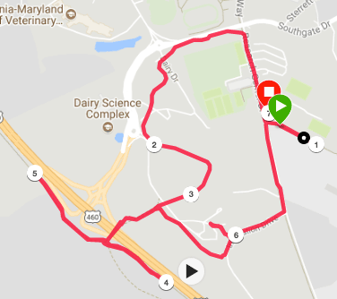
December 22, 2017: The image shows the new HT section that starts from near the new tunnel to Research Center Drive. We wanted to find the distance on the new trail from old mile-marker 1 ((1) on the image) to old mile marker 2 ((4) on the image). It is about 1.84 miles, so the new section adds about 0.84 miles. The old 1.5 mile line is approximately at (3), and the distance from (3) to (4) is 0.54 miles. There is about a 50 foot net elevation change between the beginning and end of the brand new section, but the new route has an additional “valley” of about -/+ 40 feet in elevation change.
|
December 13, 2017: From VT University Relations:
Southgate Drive from the new traffic circle to U.S. 460 will close permanently at 6:30 p.m. on Dec. 13.
A traffic pattern that utilizes the "Diverging Diamond" on the new bridge should open by 9 a.m. on Dec. 14.
Drivers to Virginia Tech's campus who normally turn onto Southgate Drive from U.S. 460 will need to use the exits at either Prices Fork Road or Research Center Drive to access the campus until the new bridge opens.
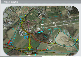 |
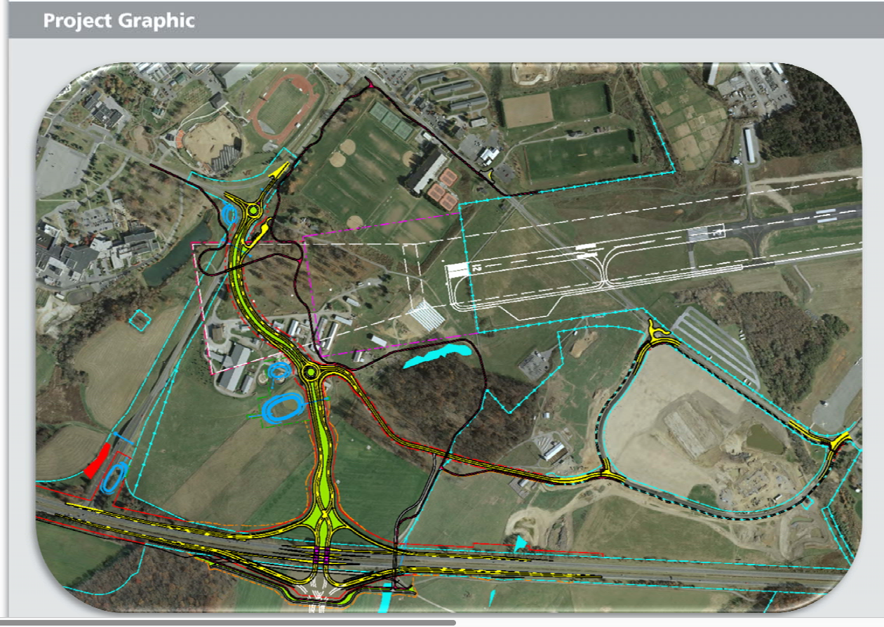
Fall 2017 (most recent update): VDOT Report on the Southgate Connector — Blacksburg
The report contains links to several videos showing in detail the changes in roads, etc. The timeline in this link to the report is updated as work is completed. |
November 30, 2017: The paving is done on the HT from Innovation and Discovery Drives through the two tunnels and both along the bypass (towards the Mile 2 marker) and also through Center Woods to Plantation Drive.
Source: Virginia Tech |
September 11, 2016:
A Roanoke Times article, with the same content as the Virginia Tech News article below has this image. |
August 10, 2016: After the 3+ inches of rain last week, there was a couple of inches of mud on both sides of the 460-Bypass tunnel — most likely caused by dirt from the demolishment of the farm-road tunnel. Plus there were deep ruts in the first gravel stretch of gravel to the east of the tunnel on the south side. As of today, the gravel stretches east of the tunnel have been smoothed and the barricade south of the tunnel on the path heading towards the woods is now open. July 25, 2016: By late afternoon, the detour between the farm-road tunnel and Research Center Drive was completed, and the work between the 460 tunnel and the mile-two marker (about 1/4 mile east of the tunnel) was done with a short gravel section for the path. The new detour adds about 1/3 mile. July 20, 2016: The section of the Huckleberry Trail between the existing underpass under the old farm road and existing Research Center Drive will be closed Thursday, July 21 at 7 a.m. and will remain closed until work is complete on the new underpass for the new Research Center Drive. Barricades will be installed at the closure points of the trail and detour signs will be installed to direct pedestrians and bikers along the proposed detour. The detour will be as follows:
- From Blacksburg toward Route 460 underpass: Turn left on Research Center Drive, right on Innovation Drive, right on the bike path along the left of existing Discovery Drive, which becomes a gravel road going down to the 460-Bypass tunnel.
- From Route 460 underpass toward Blacksburg: Turn right on existing Discovery Drive, left on Innovation Drive, left on existing Research Center Drive, then right onto Huckleberry Trail.
Pedestrians and Bikers should use caution as trucks and heavy equipment will be in operation in the area. Link to detour
July 18, 2016: The Huckleberry Trail, south of Route 460, approximately 1/4 mile east of the underpass will be closed tonight July 18 and Tuesday, July 19, between the hours of 9 p.m. and 5:30 a.m. The trail will be re-established temporarily to allow pedestrians to pass through the work area during the day; however pedestrians and bikers should use caution.
The closure is needed for drainage and utility installation under the Huckleberry Trail. The trail closure is during the trail's normal closure hours from dawn to dusk.
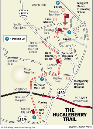
November 24, 2015: One improvement Friends of the Huckleberry is planning, and will fund, is the installation of new mileage bollards on the Huckleberry North trail from the tunnel to the Jefferson National Forest. There will be a zero mileage bollard, identical to the ones already in use along the existing trail, placed at the intersection of the Huckleberry and the Huckleberry North. We will also place a bollard at each mile mark on the way to the Jefferson National Forest with a bollard at the terminus in the Gateway Park at the base of Brush Mountain. The existing bollards on the Huck will also require relocation, since the distance of the trail is being increased. Each marker from the two-mile marker to the 5.76 mile marker at the NRV Mall will have to be moved somewhere closer to Blacksburg once all the construction is completed. We are also purchasing additional markers for the section of the Huckleberry that was extended into Christiansburg. It should soon be about 8 miles from the library in Blacksburg to the Rec Center in Christiansburg. (Bill Ellenbogen) November 24, 2015: Draft of Map showin proposed HT detour. Attached is a sketch that shows the upcoming detour of the trail. This detour is needed to widen the tunnel where the trail goes under the farm road (at the south end of the detour), which will be the new Research Center Drive at project completion. (Mike Dunn) November 20, 2015: Draft of Map for Southgate Interchange showing Huckleberry Trail. This “proposed sketch” was provided by Michael Dunn. The thinner yellow lines are the trail. Note that the lead-in to the 460 tunnel will no longer have a sharp turn. The barriers on the south side of the 460 tunnel will be replaced by a roundabout. At present, between the tunnels the paved trail has been removed and the farm road has been moved to the west just above the tunnel to eliminate the sharp turn. Weather permitting, that section of the trail will be paved before winter. Note that there is a second roundabout just south of the second tunnel. July 1, 2015: Long-awaited Huckleberry Trail bridge opens in Christiansburg (article in the The Roanoke Times. April 7, 2014: New Bikeway expands Huckleberry Trail Richard Cobb has provided a A VT News article describes the now-open-to-the=public 1-mile section between the HT at the 460 tunnel to Plantation Road. As you can see from the picture, the phones are not yet operational. Work will soon begin on the new 460 interchange near the tunnel, which will require a change in the part of that trail near the tunel. Take care on the downhill S-shaped section between the two phones when traveling towards Plantation Road, as there was a single-bike accident last Wednesday resulting in a concussion. July 26, 2013: The two-tunnel connector has been completed and paved. This new piece of the Huckleberry Trail runs from the 460 tunnel through which the HT goes to Plantation Road, which in turn connects to the Hethwood Bike Path. The new segment parallels Rt. 460 and is 0.93 miles long. At the tunnel end, there is a series of gates similar to those at the University Mall termination of the HT. At the Plantation Rd. end, there is a post to keep vehicles from accessing the trail. One practical feature is that the new segment allows along-awaited bike-friendly connection between Hethwood and the CRC.
Here are some (slightly edited) comments from Bill Ellenbogen, President, Friends of the Huckleberry, Inc:
At this time, the northernmost point of the Huckleberry North is located at the edge of a Virginia Tech Farm to the north of Prices Fork Road. Mileages for the new section of the Trail at the present time are as follows:
- 0.98 Miles current northernmost point of trail to fire station on PFR;
- 1.22 miles — Fire station to Stroubles Creek Bridge on the Hethwood Bike Path;
- 0.24 miles — Bridge to Plantation Rd;
- 3.37 miles — TOTAL DISTANCE NORTH END TO TUNNEL
- 7.74 miles — TOTAL DISTANCE NORTH END TO RTE. 114;
The above distances do not include the section of the Huckleberry Trail (approximately 1.75 miles) from the 460 tunnel to Miller Street. From Miller Street to Route 114 is approximately 6 miles.
An extension at the southern end of the Huckleberry is under construction. The Town of Christiansburg and VODT are constructing a pedestrian bridge for the Huckelberry Trail across Route 114 and will complete the Trail to the Christiansburg High School by fall of 2014. January 6, 2013 Report: In response to the page with two images for the newest section of the bike path, Bill Ellenbogen, President of Friends of the Huckleberry Trail, sent me the following update:
The section of the Huckleberry North that you reference has been planned for many years. There are environmental issues the Town is working through where the Trail stops. Federal wetland permits are required and it takes a long time to work through the process to obtain them.
The section that has been constructed was completed using grant funds that were shifted from another Trail project. This was done in order to satisfy terms of the easement granted by the Obenshains when they allowed the Trail to be constructed on the border of their property. They specified that it had to be constructed within five years of the creation of the easement so the Town installed it way ahead of the deadline. Once the environmental issues are cleared up, which will happen, the rest of the Trail, connecting to Glade Road and the Heritage Park and the Jefferson National Forest, will be constructed.
The contract to construct the section of the Huckleberry North Trail on the west side of 460, connecting the tunnel to Plantation Road, has been issued. The contractor should complete this section of the Trail by the summer of 2013.
The Renva Knowles Bridge over route 114 in Christiansburg should also be installed in 2013. Christiansburg plans to have the section of Trail from the New River Valley Mall to the Christiansburg HS completed by summer, 2014.
By summer, 2014, the Huckleberry should be completed from CHS to the Jefferson National Forest.
Eagle Scout completes project on Huckleberry Trail. The link takes you to an article in the Roanoke Times (December 2, 2012). “After 184 hours of planning, designing, requesting and building, the project culminated on Oct. 20, when a uniquely designed kiosk with informational panels was completed on the Huckleberry Trail in Christiansburg.” May 2012: The first mile of the Huckleberry Trail was widened about 2 feet (to match the bridge width). The widened path extends from Miller Street (Mile 0) to the gazebo (mile 3/4) and then towards Airport Road. The part along the gravel road was not widened.
Blacksburg launches expansion of Huckleberry Trail (Collegiate Times, February 20, 2012).
November 9, 2011: The bridge on the HT over Southgate Drive (1/2 mile from Miller Street) showed signs of rust so was closed in June. Over the summer, a new bridge was installed and the stairs from the trail to the street level were also replaced (with ones that are more bike friendly). The new bridge is 12' wide — two feet wider than the old bridge. The work was completed before the end of October.
June 8, 2011 : Huckleberry Trail Improvements (from Blacksburg Alert)
Several construction projects over the next month may cause minor delays along the Huckleberry Trail starting June 13.
-
Several bridges will receive new wooden decking and railing, causing either that trail section to close temporarily or delays up to 15 minutes, according to Parks and Recreation Director Mitchell Haugh. Two of the bridges are between Hightop and Merrimac and one bridge is between Merrimac and Christiansburg. There will be signage posted before the bridges when there are delays.
-
On June 20–21, a new restroom facility will be installed in the Coal Miners Park area. The toilet facility is being paid for by donations from the Friends of the Huckleberry, a private donor and a contribution from the County.
Huckleberry Trail is sprouting Trail organizers are doing some pruning as they build out the trail — including repairing a rusting bridge in Blacksburg (by Lerone Graham, June 2, 2011). This feature article in the Roanoke Times NRV Current has updates of many of the above threads. For example, the replacement bridge has been ordered, and it will be two feet wider than the old bridge.
October 21, 2010 update: The extension from the New River Mall to (but not crossing) Route 114 is now paved. Here is a report from a usually reliable source: “The length of extension is 0.40 miles.
The distance from the 5.5 mile mark to the end of the extension is 0.60 miles,
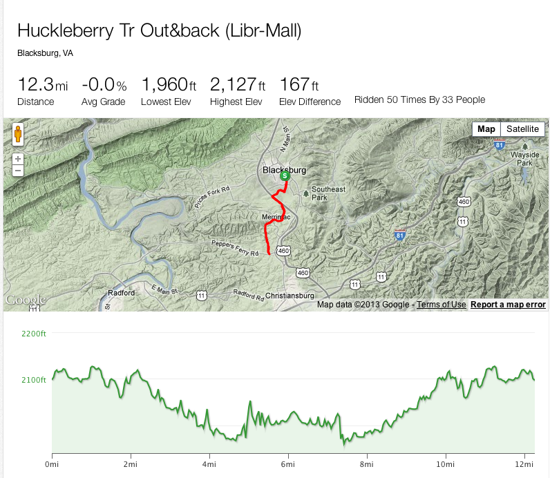
The distance from 0.0 mile mark to 5.5 mile mark is 5.48 miles.” From the 0-mile mark at Miller Street to Rout 114 and back is thus 12.2 miles. Extra credit will be given to anyone who can tell us with some certainty what the starting point will be for a round trip equal to a half marathon. (Bollo’s?)
Hopefully, in Spring 2011, the two-tunnel connector, which will link the Huckleberry Trail to the Hethwood bike path, will be completed. The Town of Blacksburg Parks/Greenways site now says Fall 2011 (May 11).
October 1, 2010 report: The paving of the additional section of Trail behind the NRV Mall will be done in the
next couple of weeks. It has been authorized to go
forward with Friends of the Huckleberry paying the $28,000 cost.
Here is an aerial view of the extension near the NRV mall. Although the funding is in place for the bridge over Route 114, it is not known at this time when that part will be completed.
In June 2006, this article reported about the completion of Phase I, the first of a planned two-phase project to connect the Huckleberry trail to the Hethwood bike paths. Two Collegiate Times articles: June 2008 and June 2010, discuss two further expansions: extending the trail from the New River Valley Mall over Route 114 to downtown Christiansburg, and an extension from Hethwood to the Jefferson National Forest where it touches Glad Road.
 Striders home page Striders home page
Last updated 13 September 2021
|